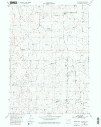
1953 Map of Savageton
USGS Topo · Published 1980About this map
The settlement of Savageton and its surrounding ranchlands characterize this mid-century survey of Campbell County. Located along the drainages of Greasewood Creek and Mud Spring Creek, the landscape is defined by a sparse but vital network of family-operated livestock operations, including the H Schlautmann Ranch, Gilbertz Ranch, and Niles Ranch. The prevalence of scattered windmills across the sections indicates the critical importance of groundwater management for sustaining the regional economy in this arid portion of Wyoming.
Find a feature on this map
19 named features on this map. Tap any name to fly to it.
Don’t see what you’re looking for? This feature index may not catch every label — zoom into the map to look around manually.
Map Details
Editions of this 1953 Savageton Map
3 editions found
Other maps of this area

1953 · Savageton
USGS Topo · 1:24,000

1953 · Fats Draw
USGS Topo · 1:24,000

1953 · South Butte
USGS Topo · 1:24,000

1953 · Rolling Pin Ranch
USGS Topo · 1:24,000

1953 · North Butte
USGS Topo · 1:24,000

1955 · Newcastle
USGS Topo · 1:250,000

1958 · Newcastle
USGS Topo · 1:250,000

1959 · Savageton
USGS Topo · 1:62,500

1959 · North Star School
USGS Topo · 1:62,500

1960 · Turnercrest
USGS Topo · 1:62,500