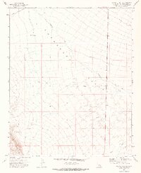
1971 Map of Savahia Peak NW
USGS Topo · Published 1973About this map
The Chemehuevi Valley defines the landscape of this 1971 survey, showing a vast arid basin transitioning into the Turtle Mountains to the southwest. This desert terrain is etched by the broad path of Chemehuevi Wash and the smaller Gary Wash, illustrating a drainage pattern characteristic of the Mojave region. The map reveals the infrastructure of desert travel and water management through labels like Water Tank Well and various benchmark locations such as Friga 1164. Human passage through this area is marked by the presence of U.S. Route 95 and several primitive Jeep Trails that snake through the desert floor and foothills. The southwestern corner of the quadrangle highlights the higher elevations near Malapais, providing a detailed look at the interface between the low valley and the volcanic landforms of the nearby peaks.
Find a feature on this map
19 named features on this map. Tap any name to fly to it.
Don’t see what you’re looking for? This feature index may not catch every label — zoom into the map to look around manually.
Map Details
Editions of this 1971 Savahia Peak NW Map
2 editions found
Other maps of this area

1903 · Needles
USGS Topo · 1:125,000

1904 · Needles Special
USGS Topo · 1:125,000

1943 · Center Hills
USGS Topo · 1:62,500

1943 · Turtle Mts.
USGS Topo · 1:62,500

1950 · Sawtooth Range
USGS Topo · 1:62,500

1950 · Savahia Peak
USGS Topo · 1:62,500

1951 · Savahia Peak
USGS Topo · 1:62,500

1951 · Sawtooth Range
USGS Topo · 1:62,500

1954 · Needles
USGS Topo · 1:250,000

1954 · Turtle Mountains
USGS Topo · 1:62,500