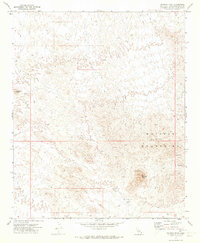
1971 Map of Savahia Peak
USGS Topo · Published 1973About this map
The Whipple Mountains dominate this 1970s landscape, a rugged terrain defined by significant mineral exploration and desert navigation. Centered on the prominent Savahia Peak, the topography reveals a network of Jeep Trails connecting isolated mining claims and geologic prospects. These trails weave through the desert washes and ridges, providing the only access to numerous small-scale operations like the Gold Hill Mine and the Gold Standard Mine.
Find a feature on this map
15 named features on this map. Tap any name to fly to it.
Don’t see what you’re looking for? This feature index may not catch every label — zoom into the map to look around manually.
Map Details
Editions of this 1971 Savahia Peak Map
This is the sole edition of this map. No revisions or reprints were ever made.
Other maps of this area

1911 · Parker
USGS Topo · 1:125,000

1943 · Whipple Mts.
USGS Topo · 1:62,500

1943 · Parker
USGS Topo · 1:62,500

1943 · Vidal
USGS Topo · 1:62,500

1949 · Parker
USGS Topo · 1:62,500

1949 · Vidal
USGS Topo · 1:62,500

1950 · Parker
USGS Topo · 1:62,500

1950 · Vidal
USGS Topo · 1:62,500

1950 · Whipple Mts
USGS Topo · 1:62,500

1950 · Savahia Peak
USGS Topo · 1:62,500