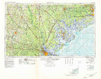
1957 Map of Savannah
USGS Topo · Published 1978About this map
The Savannah River valley anchors this 1978 revision, marking the dividing line between Georgia and South Carolina as it winds toward the Atlantic. The city of Savannah serves as the regional hub, surrounded by a heavy military and industrial presence including Hunter Air Force Base and the expansive Fort Stewart Military Reservation. To the north, the landscape is defined by the dense river networks of the Salkehatchie River and Combahee River, while the coast features the intricate barrier islands of the Lowcountry.
Find a feature on this map
137 named features on this map. Tap any name to fly to it.
Don’t see what you’re looking for? This feature index may not catch every label — zoom into the map to look around manually.
Map Details
Editions of this 1957 Savannah Map
4 editions found

Other maps of this area

1918 · Walterboro
USGS Topo · 1:62,500

1918 · Kiawah Island
USGS Topo · 1:21,120

1918 · Hinesville
USGS Topo · 1:62,500

1918 · Green Pond
USGS Topo · 1:62,500

1918 · Varnville
USGS Topo · 1:62,500

1918 · Yemassee
USGS Topo · 1:62,500

1918 · Cottageville
USGS Topo · 1:62,500

1918 · Oliver
USGS Topo · 1:62,500

1919 · Ladson
USGS Topo · 1:21,120

1919 · Johns Island
USGS Topo · 1:21,120