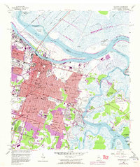
1955 Map of Savannah
USGS Topo · Published 1973About this map
Bonaventure Cemetery and Laurels Grove Cemetery anchor the burial grounds of this coastal city, which is defined by its strategic position along the Savannah River. The map shows a transition from the industrial and rail-heavy northern waterfront, dominated by the Seaboard Coast Line and Central of Georgia RR, to the suburban expansion into neighborhoods like Ardsley Park and Fairway Oaks. To the south and east, the landscape dissolves into the tidal marshlands of Oatland Island and Whitemarsh Island, separated by the winding Intracoastal Waterway. This 1955 survey, updated with 1971 urban expansions, captures the footprint of Hunter Army Airfield and educational institutions like Savannah State College. The juxtaposition of 19th-century history at Fort Jackson with mid-century residential growth highlights the city's evolution from a river port to a modern regional center.
Find a feature on this map
177 named features on this map. Tap any name to fly to it.
Don’t see what you’re looking for? This feature index may not catch every label — zoom into the map to look around manually.
Map Details
Editions of this 1955 Savannah Map
3 editions found
Other maps of this area

1920 · Wassaw Sound
USGS Topo · 1:62,500

1920 · Bluffton
USGS Topo · 1:62,500

1942 · Savannah
USGS Topo · 1:62,500

1944 · Ossabaw Island
USGS Topo · 1:62,500

1945 · Bluffton
USGS Topo · 1:62,500

1945 · Ossabaw Island
USGS Topo · 1:62,500

1945 · Wassaw Sound
USGS Topo · 1:62,500

1946 · Brunswick
USGS Topo · 1:250,000

1947 · Savannah
USGS Topo · 1:250,000

1948 · Brunswick
USGS Topo · 1:250,000