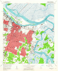
1955 Map of Savannah
USGS Topo · Published 1964About this map
Savannah stands as a complex rail and river hub in the mid-1950s, defined by the winding course of the Savannah River and its numerous marshy islands. The city's growth is clearly mapped through established neighborhoods like Ardsley Park and Derenne Sch, stretching southward toward the massive footprint of the Hunter Air Force Base. The riverfront is a dense industrial corridor of canals and rail lines, including the Central of Georgia and Atlantic Coast Line, which serviced the bustling docks and warehouses near Hutchinson Island.
Find a feature on this map
113 named features on this map. Tap any name to fly to it.
Don’t see what you’re looking for? This feature index may not catch every label — zoom into the map to look around manually.
Map Details
Editions of this 1955 Savannah Map
3 editions found
Other maps of this area

1920 · Wassaw Sound
USGS Topo · 1:62,500

1920 · Bluffton
USGS Topo · 1:62,500

1942 · Savannah
USGS Topo · 1:62,500

1944 · Ossabaw Island
USGS Topo · 1:62,500

1945 · Bluffton
USGS Topo · 1:62,500

1945 · Ossabaw Island
USGS Topo · 1:62,500

1945 · Wassaw Sound
USGS Topo · 1:62,500

1946 · Brunswick
USGS Topo · 1:250,000

1947 · Savannah
USGS Topo · 1:250,000

1948 · Brunswick
USGS Topo · 1:250,000