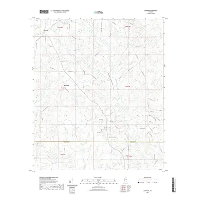
2020 Map of Savannah
USGS Topo · Published 2020About this map
Savannah and Rowlands anchor this 2020 landscape in southern Mississippi, where the headwaters of several drainages carve into the terrain. The map captures a transition point at the Pearl River Co / Hancock Co line, defined by the winding paths of Catahoula Cr and Hickory Cr. Much of the area is characterized by a dense network of local roads named for prominent families and local geography, including Savannah Millard Rd and McNeill McHenry Rd. Notable landmarks for local historians include the Steep Hollow Cem and Anner Cem, which reflect the long-standing community foundations in this rural corridor. The presence of Gilberts Lake and numerous small streams like Redfish Cr and Pen Br suggests a landscape defined by its hydrology and timber-rich environment.
Find a feature on this map
83 named features on this map. Tap any name to fly to it.
Don’t see what you’re looking for? This feature index may not catch every label — zoom into the map to look around manually.
Map Details
Editions of this 2020 Savannah Map
This is the sole edition of this map. No revisions or reprints were ever made.
Other maps of this area

1953 · Mobile
USGS Topo · 1:250,000

1955 · Savannah
USGS Topo · 1:62,500

1957 · Mobile
USGS Topo · 1:250,000

1958 · Carnes
USGS Topo · 1:62,500

1958 · Picayune
USGS Topo · 1:62,500

1959 · Poplarville
USGS Topo · 1:62,500

1960 · Mobile
USGS Topo · 1:250,000

1963 · Mobile
USGS Topo · 1:250,000

1965 · Mobile
USGS Topo · 1:250,000
1982 · Necaise
USGS Topo · 1:24,000