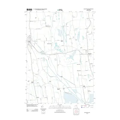
2013 Map of Savannah
USGS Topo · Published 2013About this map
The Clyde River and the historic path of Clintons Ditch define the low-lying wetlands of this landscape, including a portion of the Montezuma National Wildlife Refuge. The map details the transition from the village of Clyde in the west to the town of Savannah in the east, connected by the northern and southern corridors of Old Route 31. Dozens of crossroads and family-named corners such as Daboll Corners, Wiley Corner, and Munsons Corner provide a rich resource for genealogists tracing ancestral homesteads near the Crusoe Lake basin. Notable burial sites like Aurand Cem and the Wilsey Farm Cem are carefully noted alongside local infrastructure like the Armitage Bridge and the Savannah Agri-Air Airport. The terrain is characterized by distinctive elevations including Hogback Ridge and Fort Hill rising above the marshy flats of Crusoe Island.
Find a feature on this map
78 named features on this map. Tap any name to fly to it.
Don’t see what you’re looking for? This feature index may not catch every label — zoom into the map to look around manually.
Map Details
Editions of this 2013 Savannah Map
This is the sole edition of this map. No revisions or reprints were ever made.
Other maps of this area

1899 · Auburn
USGS Topo · 1:62,500

1902 · Geneva
USGS Topo · 1:62,500

1902 · Clyde
USGS Topo · 1:62,500

1902 · Weedsport
USGS Topo · 1:62,500

1902 · Auburn
USGS Topo · 1:62,500

1943 · Lyons
USGS Topo · 1:31,680

1943 · Geneva North
USGS Topo · 1:31,680

1943 · Montezuma
USGS Topo · 1:31,680

1943 · Cayuga
USGS Topo · 1:31,680

1943 · Savannah
USGS Topo · 1:31,680