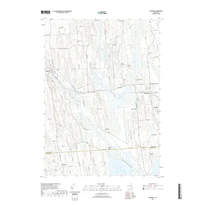
2019 Map of Savannah
USGS Topo · Published 2019About this map
The Clyde River and the historic path of the Erie Canal dominate this portion of Wayne County, illustrating a landscape defined by its waterways and glacial drumlins. The village of Clyde occupies the northwest corner, while Savannah sits to the east, connected by a network of rural roads and the former Trolley Bed. This 2019 survey shows the extensive wetlands of the Montezuma National Wildlife Reserve and Montezuma Marsh, where the Clinton Ditch and Black Creek weave through the lowlands between pronounced elevations like Messner Hill and Hogback Ridge. For genealogists, the map is a primary resource for locating several family-named burial grounds, including Herrington Cem, Wiley Cem, and the Wilsey Farm Cem. The transition from the settled streets of Clyde to the vast reaches of Crusoe Lake and Tamarack Swamp highlights the enduring role of the regional drainage systems in shaping local land use.
Find a feature on this map
109 named features on this map. Tap any name to fly to it.
Don’t see what you’re looking for? This feature index may not catch every label — zoom into the map to look around manually.
Map Details
Editions of this 2019 Savannah Map
This is the sole edition of this map. No revisions or reprints were ever made.
Other maps of this area

1899 · Auburn
USGS Topo · 1:62,500

1902 · Geneva
USGS Topo · 1:62,500

1902 · Clyde
USGS Topo · 1:62,500

1902 · Weedsport
USGS Topo · 1:62,500

1902 · Auburn
USGS Topo · 1:62,500

1943 · Lyons
USGS Topo · 1:31,680

1943 · Geneva North
USGS Topo · 1:31,680

1943 · Montezuma
USGS Topo · 1:31,680

1943 · Cayuga
USGS Topo · 1:31,680

1943 · Savannah
USGS Topo · 1:31,680