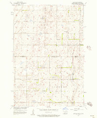
1956 Map of Savo NE
USGS Topo · Published 1957About this map
Agricultural lands along the state line between North Dakota and South Dakota define this mid-century landscape, surveyed for the development of the Missouri River Basin. The prairie is marked by a network of rural schoolhouses and neighborhood churches, reflecting the community structure of Ada, Savo, and Liberty townships. Small, family-centric landmarks like the Youngman Sch and Engle Sch sit amidst a terrain punctuated by water features such as Cannon Run and Flowing Well. Cultural heritage is particularly evident in the presence of the Finnish Ch and St Marks Ch, which served the local farming population near the Dickey and Brown County line. The reliance on intermittent water sources is seen in the meandering path of Dry Run, while a solitary Cem stands as a quiet record of early settlers in this border region.
Find a feature on this map
16 named features on this map. Tap any name to fly to it.
Don’t see what you’re looking for? This feature index may not catch every label — zoom into the map to look around manually.
Map Details
Editions of this 1956 Savo NE Map
This is the sole edition of this map. No revisions or reprints were ever made.
Other maps of this area

1894 · Hecla
USGS Topo · 1:62,500

1894 · Savo
USGS Topo · 1:62,500

1894 · Fullerton
USGS Topo · 1:62,500

1894 · Oakes
USGS Topo · 1:62,500

1895 · Lamoure
USGS Topo · 1:125,000

1896 · Columbia
USGS Topo · 1:125,000

1918 · La Moure
USGS Topo · 1:125,000

1953 · Jamestown
USGS Topo · 1:250,000

1953 · Savo SW
USGS Topo · 1:24,000

1953 · Houghton
USGS Topo · 1:24,000