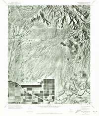
1971 Map of Sawik Mountain
USGS Topo · Published 1972About this map
McDowell Mts dominate the northern landscape of this 1971 orthophotomosaic, where rugged peaks give way to a dramatic alluvial fan that spreads toward the valley floor. This unique photographic record captures the stark transition from the mountain terrain to the burgeoning agricultural and irrigation infrastructure of Maricopa County. The Arizona Canal cuts a definitive line across the lower third of the map, serving as the primary lifeline for the gridded fields and orchards that appear in the southwest. Between the peaks and the canal, the landscape is defined by complex drainage patterns and the isolated rise of Sawik Mtn. The aerial photography provides a rare view of the land's texture before widespread residential development, highlighting the critical relationship between the desert topography and the water management systems that enabled the region's mid-century growth.
Find a feature on this map
3 named features on this map. Tap any name to fly to it.
Don’t see what you’re looking for? This feature index may not catch every label — zoom into the map to look around manually.
Map Details
Editions of this 1971 Sawik Mountain Map
This is the sole edition of this map. No revisions or reprints were ever made.
Other maps of this area

1904 · Camelback
USGS Topo · 1:62,500

1904 · Desert Well
USGS Topo · 1:62,500

1904 · Ft. McDowell
USGS Topo · 1:62,500

1906 · Camelsback
USGS Topo · 1:62,500

1906 · Ft. McDowell
USGS Topo · 1:62,500

1906 · Desert Well
USGS Topo · 1:62,500

1913 · Mesa
USGS Topo · 1:62,500

1915 · Mesa
USGS Topo · 1:62,500

1930 · Cave Creek
USGS Topo · 1:125,000

1939 · Cave Creek
USGS Topo · 1:125,000