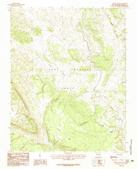
1983 Map of Sawmill Mesa
USGS Topo · Published 1983About this map
The Tierra Amarilla Grant defines much of this high-elevation landscape in Rio Arriba County, showcasing a complex system of plateaus and seasonal water sources in the early 1980s. Centered on the prominent Sawmill Mesa, the terrain is marked by dramatic elevation changes at the Tecolote Rim and the sheer face of Tecolote Mesa. This manuscript-based survey captures the sparse human footprint in the region, noting the Casa Escobedida settlement along the eastern edge of the quadrangle. Water is the primary driver of geography here, with numerous vital points such as Cebadilla Spring, North Cebadilla Spring, and Tijera Spring supporting life in the drainage basins of Willow Creek. Deep cuts like the Cañada de Tio Roque and Cañada de la Laguna illustrate how erosion has shaped the local topography south of El Cerro.
Find a feature on this map
12 named features on this map. Tap any name to fly to it.
Don’t see what you’re looking for? This feature index may not catch every label — zoom into the map to look around manually.
Map Details
Editions of this 1983 Sawmill Mesa Map
This is the sole edition of this map. No revisions or reprints were ever made.
Other maps of this area

1954 · Aztec
USGS Topo · 1:250,000

1955 · Chama
USGS Topo · 1:62,500

1955 · Lumberton
USGS Topo · 1:62,500

1955 · Tierra Amarilla
USGS Topo · 1:62,500

1955 · Boulder Lake
USGS Topo · 1:62,500

1958 · Aztec
USGS Topo · 1:250,000

1962 · Aztec
USGS Topo · 1:250,000

1965 · Aztec
USGS Topo · 1:250,000

1981 · Chama
USGS Topo · 1:100,000
1983 · Monero
USGS Topo · 1:24,000