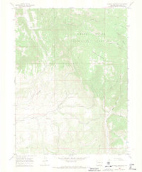
1966 Map of Sawmill Mountain
USGS Topo · Published 1970About this map
The White River National Forest defines this high-elevation landscape in Rio Blanco County, characterized by a complex network of drainages and mountain ridges during the mid-1960s. Resource extraction and backcountry access are evident through numerous mines and prospects scattered across the northern slopes, particularly near Coal Creek. The terrain is navigated by a system of jeep trails and pack trails that link landmarks like Sawmill Mountain and Hay Park. Water management is represented by the Feeder Ditch in the northeast, while the southern portion of the quadrangle is dominated by the confluence of Beaver Creek and its many tributaries, including Little Beaver Creek and East Beaver Creek. This survey captures the area before modern development, showing the primitive road network and various drill holes that suggest a landscape shaped by both natural wilderness and geological exploration.
Find a feature on this map
27 named features on this map. Tap any name to fly to it.
Don’t see what you’re looking for? This feature index may not catch every label — zoom into the map to look around manually.
Map Details
Editions of this 1966 Sawmill Mountain Map
3 editions found
Other maps of this area

1906 · Grand Hogback
USGS Topo · 1:125,000

1910 · Danforth Hills
USGS Topo · 1:125,000

1910 · Grand Hogback
USGS Topo · 1:125,000

1912 · Meeker
USGS Topo · 1:62,500

1914 · Meeker
USGS Topo · 1:62,500

1954 · Craig
USGS Topo · 1:250,000

1957 · Craig
USGS Topo · 1:250,000

1957 · Leadville
USGS Topo · 1:250,000

1958 · Craig
USGS Topo · 1:250,000

1959 · Leadville
USGS Topo · 1:250,000