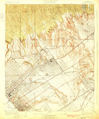
1925 Map of Sawtelle
USGS Topo · Published 1925About this map
Soldiers Home and the adjacent settlement of Sawtelle anchor this mid-1920s survey, showing West Los Angeles during a period of rapid suburban and recreational expansion. The grid of Sawtelle is densely developed, flanked by the massive landholdings of the Los Angeles Country Club and the San Jose De Buenos Ayres rancho. Transportation is dominated by the Pacific Electric rail lines, which connect the coast at Santa Monica Bay to inland centers like Beverley Hills. The map captures an era of specialized land use, from the Aviation Field in the southern flats of La Ballona to the numerous hothouses dotting the landscape. In the north, the steep Santa Monica Mountains remain largely undeveloped, carved by canyons such as Sepulveda Canyon and Benedict Canyon, providing a sharp contrast to the burgeoning valley below.
Find a feature on this map
50 named features on this map. Tap any name to fly to it.
Don’t see what you’re looking for? This feature index may not catch every label — zoom into the map to look around manually.
Map Details
Editions of this 1925 Sawtelle Map
2 editions found
Other maps of this area

1894 · Los Angeles
USGS Topo · 1:62,500

1896 · Redondo
USGS Topo · 1:62,500

1896 · Santa Monica
USGS Topo · 1:62,500

1898 · Santa Monica
USGS Topo · 1:62,500

1900 · Los Angeles
USGS Topo · 1:62,500

1901 · Southern California Sheet No. 1
USGS Topo · 1:250,000

1902 · Santa Monica
USGS Topo · 1:62,500

1903 · Calabasas
USGS Topo · 1:62,500

1903 · Camulos
USGS Topo · 1:125,000

1904 · Southern California Sheet No. 1
USGS Topo · 1:250,000