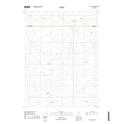
2018 Map of Sawtooth Knob
USGS Topo · Published 2018About this map
Sawtooth Knob dominates the high desert terrain of northern Nevada, marking a prominent point of elevation in a landscape defined by deep drainages and intermittent water sources. This 2018 survey captures the remote character of the borderlands between Humboldt and Pershing counties, where the geological features suggest a history of seasonal water reliance. Important natural landmarks like Railroad Spring and Mitchum Spring are documented alongside the significant erosional features of Box Canyon and Rosebud Canyon. The map reveals a transition from the higher peaks near the knob down into the wider expanse of Long Canyon in the southeast, illustrating the complex topography that historically influenced movement and land use in this part of the Great Basin.
Find a feature on this map
13 named features on this map. Tap any name to fly to it.
Don’t see what you’re looking for? This feature index may not catch every label — zoom into the map to look around manually.
Map Details
Editions of this 2018 Sawtooth Knob Map
This is the sole edition of this map. No revisions or reprints were ever made.
Other maps of this area

1931 · Lovelock
USGS Topo · 1:250,000

1935 · Lovelock
USGS Topo · 1:250,000

1955 · Lovelock
USGS Topo · 1:250,000

1959 · Lovelock
USGS Topo · 1:250,000

1971 · Majuba Mtn
USGS Topo · 1:24,000
1971 · Jungo
USGS Topo · 1:24,000
1971 · Long Canyon
USGS Topo · 1:24,000
1981 · Sawtooth Knob
USGS Topo · 1:24,000

1981 · Scossa
USGS Topo · 1:24,000

1981 · Placerites
USGS Topo · 1:24,000