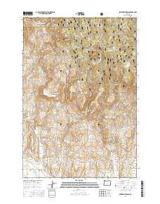
2014 Map of Sawtooth Ridge
USGS Topo · Published 2014About this map
The Lower Powder Valley provides a base of settlement in this high-elevation corner of Union and Baker counties. The landscape is defined by an intricate network of water management, where the Big Cr Ditch, Erwin Ditch, and Emele Ditch trace the contours of the land to divert water for local agricultural use. These man-made features contrast with the prominent volcanic and geological landmarks that dominate the horizon, including the distinctive Sawtooth Crater and the rugged heights of Sawtooth Ridge.
Find a feature on this map
47 named features on this map. Tap any name to fly to it.
Don’t see what you’re looking for? This feature index may not catch every label — zoom into the map to look around manually.
Map Details
Editions of this 2014 Sawtooth Ridge Map
This is the sole edition of this map. No revisions or reprints were ever made.
Other maps of this area

1901 · Baker City
USGS Topo · 1:125,000

1906 · Telocaset
USGS Topo · 1:125,000

1915 · Pine
USGS Topo · 1:125,000

1954 · Eagle Cap
USGS Topo · 1:62,500

1955 · Baker
USGS Topo · 1:250,000

1955 · Grangeville
USGS Topo · 1:250,000

1957 · Sparta
USGS Topo · 1:62,500

1959 · Baker
USGS Topo · 1:250,000

1959 · Grangeville
USGS Topo · 1:250,000

1965 · Flagstaff Butte
USGS Topo · 1:24,000