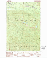
1989 Map of Sawtooth Ridge
USGS Topo · Published 1989About this map
Mt Rainier National Park borders the northern edge of this high-elevation wilderness, where the Nisqually River flows through the upper valley. This 1989 provisional map illustrates a landscape of extreme vertical relief, managed across three distinct administrative boundaries: the National Park, Snoqualmie National Forest, and Gifford Pinchot National Forest. Central to the map is Sawtooth Ridge, a sharp spine punctuated by high points like High Rock, which features a prominent Lookout station.
Find a feature on this map
36 named features on this map. Tap any name to fly to it.
Don’t see what you’re looking for? This feature index may not catch every label — zoom into the map to look around manually.
Map Details
Editions of this 1989 Sawtooth Ridge Map
This is the sole edition of this map. No revisions or reprints were ever made.
Other maps of this area

1924 · Mt Rainier
USGS Topo · 1:96,000

1928 · Mt Rainier
USGS Topo · 1:125,000

1937 · Eatonville
USGS Topo · 1:125,000

1950 · Yakima
USGS Topo · 1:250,000

1953 · Hoquiam
USGS Topo · 1:250,000

1956 · Mineral
USGS Topo · 1:62,500

1956 · Kapowsin
USGS Topo · 1:62,500

1957 · Hoquiam
USGS Topo · 1:250,000

1958 · Yakima
USGS Topo · 1:250,000

1958 · Hoquiam
USGS Topo · 1:250,000