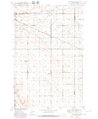
1979 Map of Sawyer NE
USGS Topo · Published 1980About this map
Surrey and New Prairie townships dominate this rural landscape in the late 1970s, where the high plains are segmented by a strictly surveyed grid of section lines and county roads. The Burlington Northern railroad cuts a diagonal path across the northern half of the quadrangle, following the natural contours of the land above the Souris R, which barely clips the southwestern corner. This area serves as a classic example of the Great Plains school district system, clearly preserving the locations of rural education centers such as Grassland School No 1 and Grassland School No 2. The map also delineates the boundary between Ward Co and Mc Henry Co along the eastern edge, showing the sparse settlement patterns and agricultural focus of North Prairie at the end of the decade.
Find a feature on this map
8 named features on this map. Tap any name to fly to it.
Don’t see what you’re looking for? This feature index may not catch every label — zoom into the map to look around manually.
Map Details
Editions of this 1979 Sawyer NE Map
This is the sole edition of this map. No revisions or reprints were ever made.
Other maps of this area

1929 · Sawyer
USGS Topo · 1:62,500

1948 · Velva
USGS Topo · 1:62,500

1948 · Sawyer
USGS Topo · 1:24,000

1948 · Surrey
USGS Topo · 1:24,000

1949 · Norwich
USGS Topo · 1:24,000

1949 · Sawyer
USGS Topo · 1:24,000

1949 · Sawyer NE
USGS Topo · 1:24,000

1949 · Deering SW
USGS Topo · 1:24,000

1949 · Velva
USGS Topo · 1:24,000

1949 · Deering SE
USGS Topo · 1:24,000