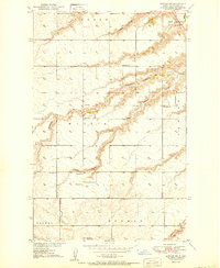
1950 Map of Sawyer SW
USGS Topo · Published 1950About this map
The northern prairies of Ward County, as documented just before the mid-century, reveal a rural landscape organized by the township and range system into distinct districts like Sundre, New Prairie, and Willis. The terrain is defined by a series of deep coulees, including Kemp Coulee and Mostad Coulee, which drain toward the Souris R in the northeast. This 1950 edition shows the area at a peak of localized rural infrastructure, where nearly every township section is served by its own numbered schoolhouse, such as School No 2 and School No 4. A glimpse of the local energy economy is visible in the southeast corner at the Lignite Mine near Oak Cr, while community life is anchored by sites like Highland Ch and the centrally located Center Cem.
Find a feature on this map
24 named features on this map. Tap any name to fly to it.
Don’t see what you’re looking for? This feature index may not catch every label — zoom into the map to look around manually.
Map Details
Editions of this 1950 Sawyer SW Map
2 editions found
Other maps of this area

1928 · Minot
USGS Topo · 1:62,500

1929 · Sawyer
USGS Topo · 1:62,500

1929 · Benedict
USGS Topo · 1:62,500

1948 · Sawyer
USGS Topo · 1:24,000

1948 · Surrey
USGS Topo · 1:24,000

1949 · Sawyer
USGS Topo · 1:24,000

1949 · Sawyer NE
USGS Topo · 1:24,000

1949 · Surrey
USGS Topo · 1:24,000

1949 · Minot
USGS Topo · 1:24,000

1949 · Sawyer
USGS Topo · 1:62,500