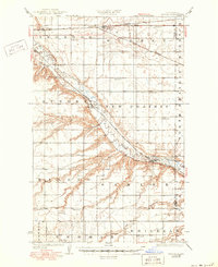
1929 Map of Sawyer
USGS Topo · Published 1950About this map
The Souris River carves a deep valley through the high prairie of Ward and McHenry Counties, defining the geographic and economic life of this region during the mid-1920s. Two major rail systems, the Great Northern and the Minneapolis St. Paul and Sault Ste. Marie, dictate the placement of settlements like Sawyer and Logan along the river's path. The map reveals a highly structured rural society organized into numbered school districts, such as School No 2 and School No 5, which served the farming townships of Newman, Willis, and Enrose. Early infrastructure is documented through crossing points like the Saugstad Bridge and Schilling Bridge, which provided vital links across the meandering river and its tributaries, including Wintering Creek and Oaks Creek. This survey captures the North Dakota landscape just as the rural schoolhouse system and rail-dependent grain economy reached their peak development.
Find a feature on this map
27 named features on this map. Tap any name to fly to it.
Don’t see what you’re looking for? This feature index may not catch every label — zoom into the map to look around manually.
Map Details
Editions of this 1929 Sawyer Map
2 editions found
Other maps of this area

1928 · Minot
USGS Topo · 1:62,500

1929 · Sawyer
USGS Topo · 1:62,500

1929 · Benedict
USGS Topo · 1:62,500

1929 · Kongsberg
USGS Topo · 1:62,500

1948 · Velva
USGS Topo · 1:62,500

1948 · Sawyer
USGS Topo · 1:24,000

1948 · Burlington
USGS Topo · 1:62,500

1948 · Surrey
USGS Topo · 1:24,000

1949 · Norwich
USGS Topo · 1:24,000

1949 · Sawyer
USGS Topo · 1:24,000