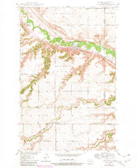
1981 Map of Sawyer
USGS Topo · Published 1981About this map
Sawyer serves as the focal point of this North Dakota landscape, situated along the Soo Line railroad where it follows the valley floor. The settlement pattern here is deeply tied to the winding course of the Souris River, which carves through the expansive reaches of New Prairie and North Prairie. This 1981 photorevised survey illustrates the intersection of rural transit and agriculture, notably where the Soo Line crosses the river near Schilling Bridge. Local landmarks such as Black Butte and Skinner Hill provide significant topographic relief against the surrounding plains. To the south, the presence of the Mennonite Ch and Sawyer Cem indicates the long-standing community centers established by early residents. The map also delineates the boundary between Ward Co and McHenry Co, tracking how administrative lines bisect the drainage basins of Oak Creek and Bonnes Coulee.
Find a feature on this map
18 named features on this map. Tap any name to fly to it.
Don’t see what you’re looking for? This feature index may not catch every label — zoom into the map to look around manually.
Map Details
Editions of this 1981 Sawyer Map
This is the sole edition of this map. No revisions or reprints were ever made.
Other maps of this area

1929 · Sawyer
USGS Topo · 1:62,500

1929 · Benedict
USGS Topo · 1:62,500

1929 · Kongsberg
USGS Topo · 1:62,500

1948 · Velva
USGS Topo · 1:62,500

1948 · Sawyer
USGS Topo · 1:24,000

1948 · Surrey
USGS Topo · 1:24,000

1949 · Norwich
USGS Topo · 1:24,000

1949 · Sawyer
USGS Topo · 1:24,000

1949 · Sawyer NE
USGS Topo · 1:24,000

1949 · Velva
USGS Topo · 1:24,000