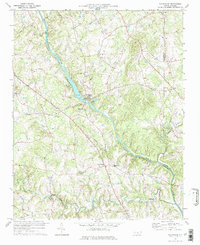
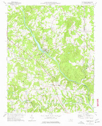
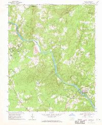
1977 Map of Saxapahaw
USGS Topo · Published 1977About this map
The Haw River carves through the center of this rural landscape, defining the boundary between Alamance and Orange Counties. The settlement of Saxapahaw serves as a focal point along the river's edge, supported by local infrastructure including a Pumping Sta and Sewage Disposal plant. Further inland, the map reveals a network of small agricultural communities and crossroads settlements such as Eli Whitney, Sutphin, and Oaks.
Find a feature on this map
29 named features on this map. Tap any name to fly to it.
Don’t see what you’re looking for? This feature index may not catch every label — zoom into the map to look around manually.
Map Details
Editions of this 1977 Saxapahaw Map
2 editions found
Other maps of this area

1953 · Raleigh
USGS Topo · 1:250,000

1953 · Greensboro
USGS Topo · 1:250,000

1954 · Greensboro
USGS Topo · 1:250,000

1954 · Raleigh
USGS Topo · 1:250,000

1962 · Greensboro
USGS Topo · 1:250,000

1966 · Greensboro
USGS Topo · 1:250,000
1968 · White Cross
USGS Topo · 1:24,000
1968 · Efland
USGS Topo · 1:24,000
1968 · Bynum
USGS Topo · 1:24,000
1969 · Burlington
USGS Topo · 1:24,000