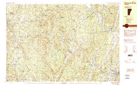
1984 Map of Saxtons River
USGS Topo · Published 1984About this map
Grafton and its surrounding hill country in the early 1980s represent a quintessential New England landscape defined by the intersection of steep terrain and tight river valleys. This topographic study reveals the importance of the Saxtons River and its branches in dictating the settlement patterns of villages like Houghtonville and Cambridgeport. The presence of the Green Mountain Railroad following the Williams River valley through Bartonsville highlights the historical reliance on rail corridors to traverse the Windsor and Windham County borderlands.
Find a feature on this map
75 named features on this map. Tap any name to fly to it.
Don’t see what you’re looking for? This feature index may not catch every label — zoom into the map to look around manually.
Map Details
Editions of this 1984 Saxtons River Map
2 editions found
Other maps of this area

1893 · Wallingford
USGS Topo · 1:62,500

1894 · Londonderry
USGS Topo · 1:62,500

1899 · Londonderry
USGS Topo · 1:62,500

1926 · Claremont
USGS Topo · 1:62,500

1927 · Bellows Falls
USGS Topo · 1:48,000

1928 · Ludlow
USGS Topo · 1:48,000

1929 · Claremont
USGS Topo · 1:62,500

1929 · Ludlow
USGS Topo · 1:62,500

1930 · Saxtons River
USGS Topo · 1:48,000

1930 · Bellows Falls
USGS Topo · 1:62,500