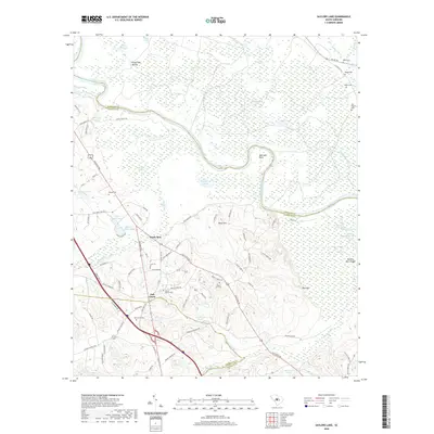
2020 Map of Saylors Lake
USGS Topo · Published 2020About this map
Sandy Run and Oak Grove sit at the center of this rural South Carolina landscape, where the Congaree River carves a winding path along the border of Richland and Calhoun counties. The river's influence is clear in the numerous oxbows and floodplain features like Saylors Lake, Roundabout Lake, and the prominent peninsula known as Bell Hall Neck. This 2020 survey reveals a community defined by its long-standing family and religious sites, such as Mount Zion Cem, Mount Moriah Cem, and Zion Pilgrim Cem. Moving away from the swampy lowlands of Mullers Swamp and Boggy Gully, the terrain rises toward Haigs Hill and Red Hill, showing a network of secondary roads such as Old State Rd and Columbia Rd that connect these agricultural and residential pockets. The topography is dotted with small, named water bodies including Struckman Pond and Jamison Pond, reflecting the localized water management of the region.
Find a feature on this map
92 named features on this map. Tap any name to fly to it.
Don’t see what you’re looking for? This feature index may not catch every label — zoom into the map to look around manually.
Map Details
Editions of this 2020 Saylors Lake Map
This is the sole edition of this map. No revisions or reprints were ever made.
Other maps of this area

1944 · Edmund
USGS Topo · 1:62,500

1946 · Woodford
USGS Topo · 1:62,500

1946 · St. Matthews
USGS Topo · 1:62,500

1948 · Hopkins
USGS Topo · 1:62,500

1953 · Saylors Lake
USGS Topo · 1:24,000

1953 · Fort Jackson South
USGS Topo · 1:24,000
1953 · Congaree
USGS Topo · 1:24,000

1953 · Gadsden
USGS Topo · 1:24,000

1954 · Augusta
USGS Topo · 1:250,000

1957 · Augusta
USGS Topo · 1:250,000