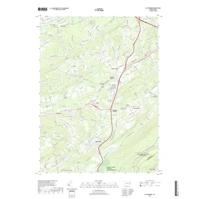
2019 Map of Saylorsburg
USGS Topo · Published 2019About this map
Saylorsburg sits at a critical geographic junction where the Cherry Valley meets the rising slopes of Kittatinny Mtn. This landscape is defined by its deep-rooted rural communities and a dense network of local burial grounds that trace the area's ancestral lines, from the Bossert - Heller Family Cem to the Christ Hamilton Lutheran Cem in Hamilton Square. The terrain is marked by significant hydrological features such as McMichael Creek and Aquashicola Cr, which historically influenced the placement of settlements like Sciota and Snydersville. To the southeast, the Appalachian National Scenic Trail traverses the ridgeline, overlooking the Cherry Valley National Wildlife Refuge. The map captures a transition from traditional agricultural lands toward conservation and recreation, evidenced by the inclusion of Pegasus Air Park and numerous protected natural areas.
Find a feature on this map
85 named features on this map. Tap any name to fly to it.
Don’t see what you’re looking for? This feature index may not catch every label — zoom into the map to look around manually.
Map Details
Editions of this 2019 Saylorsburg Map
This is the sole edition of this map. No revisions or reprints were ever made.
Other maps of this area

1891 · Delaware Water Gap
USGS Topo · 1:62,500

1893 · Delaware Water Gap
USGS Topo · 1:62,500

1914 · Wind Gap
USGS Topo · 1:62,500

1916 · Wind Gap
USGS Topo · 1:62,500

1919 · Pocono
USGS Topo · 1:62,500

1921 · Pocono
USGS Topo · 1:62,500

1923 · Pocono
USGS Topo · 1:62,500

1924 · Bushkill
USGS Topo · 1:48,000

1936 · Delaware Water Gap
USGS Topo · 1:48,000

1941 · Delaware Water Gap
USGS Topo · 1:62,500
Featured Places
- Stroud Township, PA
- Pocono Township, PA
- Plainfield Township, PA
- Hamilton Township, PA
- Jackson Township, PA