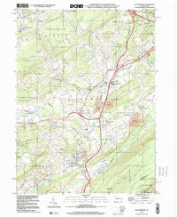
1999 Map of Saylorsburg
USGS Topo · Published 2001About this map
The intersection of several small Pocono mountain communities defines this landscape at the end of the millennium, centered on the village of Saylorsburg. Situated between Chestnut Ridge and the prominent Blue Mountain ridge, the area reveals a pattern of rural development alongside civic infrastructure. Significant institutional landmarks include the Monroe County Correctional Facility and the Pleasant Valley Manor, while the presence of numerous cemeteries like Mt Calvary Cem and Green Ridge Cem provide essential data points for local genealogists.
Find a feature on this map
63 named features on this map. Tap any name to fly to it.
Don’t see what you’re looking for? This feature index may not catch every label — zoom into the map to look around manually.
Map Details
Editions of this 1999 Saylorsburg Map
This is the sole edition of this map. No revisions or reprints were ever made.
Other maps of this area

1891 · Delaware Water Gap
USGS Topo · 1:62,500

1893 · Delaware Water Gap
USGS Topo · 1:62,500

1914 · Wind Gap
USGS Topo · 1:62,500

1916 · Wind Gap
USGS Topo · 1:62,500

1919 · Pocono
USGS Topo · 1:62,500

1921 · Pocono
USGS Topo · 1:62,500

1923 · Pocono
USGS Topo · 1:62,500

1924 · Bushkill
USGS Topo · 1:48,000

1936 · Delaware Water Gap
USGS Topo · 1:48,000

1941 · Delaware Water Gap
USGS Topo · 1:62,500
Featured Places
- Plainfield Township, PA
- Chestnuthill Township, PA
- Pocono Township, PA
- Sciota, Hamilton Township
- Stroud Township, PA