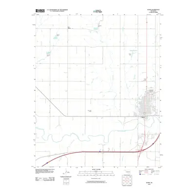
2010 Map of Sayre
USGS Topo · Published 2010About this map
Sayre serves as the focal point of this western Oklahoma landscape, where the grid of the town sits just north of a sharp bend in the North Fork Red River. The area is defined by its water management systems, characterized by numerous small-scale impoundments including Robertson Reservoir, Thurman Reservoir, and Hickey Reservoir, each supported by eponymous dams. To the north, the small settlement of New Liberty sits among a network of drainages like Turkey Creek and Long Creek. On the northern edge of the city, Southwest Oklahoma State University and the Sacred Heart Cemetery provide significant landmarks for local history and genealogy. The terrain is marked by the winding courses of Short Creek and Sand Creek as they converge toward the river valley, illustrating the critical relationship between the local geography and the agricultural water needs of the region.
Find a feature on this map
20 named features on this map. Tap any name to fly to it.
Don’t see what you’re looking for? This feature index may not catch every label — zoom into the map to look around manually.
Map Details
Editions of this 2010 Sayre Map
This is the sole edition of this map. No revisions or reprints were ever made.
Other maps of this area

1955 · Clinton
USGS Topo · 1:250,000

1957 · Clinton
USGS Topo · 1:250,000

1960 · Sweetwater
USGS Topo · 1:62,500

1960 · Sayre
USGS Topo · 1:62,500

1961 · Willow
USGS Topo · 1:62,500

1961 · Erick
USGS Topo · 1:62,500

1985 · Elk City
USGS Topo · 1:100,000
1988 · Grimes
USGS Topo · 1:24,000
1989 · Carter West
USGS Topo · 1:24,000
1989 · Erick
USGS Topo · 1:24,000