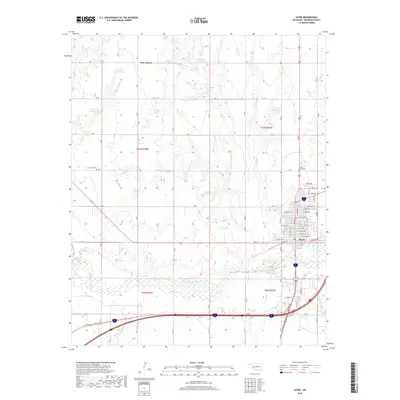
2018 Map of Sayre
USGS Topo · Published 2018About this map
The North Fork Red River winds through the southern landscape of Beckham County, Oklahoma, defining a valley that contrasts with the surrounding agricultural uplands. The city of Sayre serves as the regional anchor, featuring a traditional grid of named streets such as W Main St and N Broadway St north of the river. A network of small reservoirs, including Thurman Reservoir, Phillips Reservoir, and Hickey Reservoir, are scattered throughout the northern townships, indicating the importance of water management and irrigation in this plains environment. Local history and genealogy are anchored by rural landmarks like the Lone Oak Cem and Sacred Heart Cem, alongside the small settlement of New Liberty. This survey documents the area's modern infrastructure, including the Interstate corridor and a system of section-line roads like N 1870 Rd.
Find a feature on this map
62 named features on this map. Tap any name to fly to it.
Don’t see what you’re looking for? This feature index may not catch every label — zoom into the map to look around manually.
Map Details
Editions of this 2018 Sayre Map
This is the sole edition of this map. No revisions or reprints were ever made.
Other maps of this area

1955 · Clinton
USGS Topo · 1:250,000

1957 · Clinton
USGS Topo · 1:250,000

1960 · Sweetwater
USGS Topo · 1:62,500

1960 · Sayre
USGS Topo · 1:62,500

1961 · Willow
USGS Topo · 1:62,500

1961 · Erick
USGS Topo · 1:62,500

1985 · Elk City
USGS Topo · 1:100,000
1988 · Grimes
USGS Topo · 1:24,000
1989 · Carter West
USGS Topo · 1:24,000
1989 · Erick
USGS Topo · 1:24,000