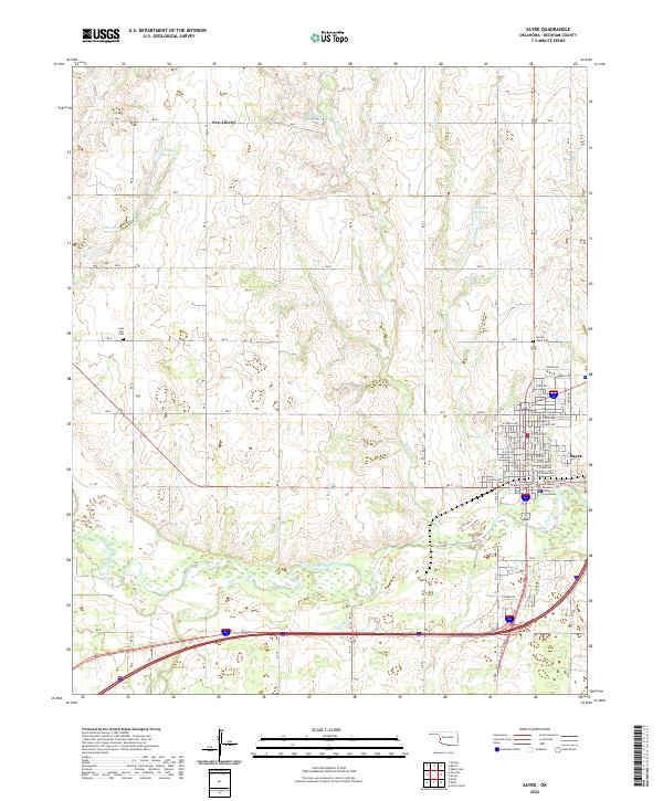
2022 Map of Sayre
USGS Topo · Published 2022About this map
The Beckham County Courthouse stands as the central landmark of Sayre, anchoring a detailed street grid that reaches from W Main St toward the southern banks of the North Fork Red River. This modern survey illustrates the persistent importance of water management in western Oklahoma, mapping several localized catchments such as Phillips Reservoir, Robertson Reservoir, and Thurman Reservoir across the northern townships. The landscape transition is evident where the structured streets of the city give way to the winding course of Turkey Cr and Sand Cr. Genealogists will find value in the precise locations of the Lone Oak Cem and Sacred Heart Cem, alongside the small settlement of New Liberty, which continues to define the rural character north of the interstate corridor.
Find a feature on this map
38 named features on this map. Tap any name to fly to it.
Don’t see what you’re looking for? This feature index may not catch every label — zoom into the map to look around manually.
Map Details
Editions of this 2022 Sayre Map
This is the sole edition of this map. No revisions or reprints were ever made.
Other maps of this area

1955 · Clinton
USGS Topo · 1:250,000

1957 · Clinton
USGS Topo · 1:250,000

1960 · Sweetwater
USGS Topo · 1:62,500

1960 · Sayre
USGS Topo · 1:62,500

1961 · Willow
USGS Topo · 1:62,500

1961 · Erick
USGS Topo · 1:62,500

1985 · Elk City
USGS Topo · 1:100,000
1988 · Grimes
USGS Topo · 1:24,000
1989 · Carter West
USGS Topo · 1:24,000
1989 · Erick
USGS Topo · 1:24,000