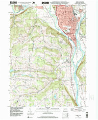
1995 Map of Sayre
USGS Topo · Published 1999About this map
The confluence of the Chemung River and Susquehanna River dominates this landscape in northern Bradford County, where the industrial and transportation history of Sayre and Athens is clearly visible. This mid-1990s record details the dense urban footprint of the river towns, including the extensive rail infrastructure of Conrail and civic landmarks like the 14th Ward Sch and Tioga Point Cemetery.
Find a feature on this map
68 named features on this map. Tap any name to fly to it.
Don’t see what you’re looking for? This feature index may not catch every label — zoom into the map to look around manually.
Map Details
Editions of this 1995 Sayre Map
This is the sole edition of this map. No revisions or reprints were ever made.
Other maps of this area

1902 · Waverly
USGS Topo · 1:62,500

1903 · Owego
USGS Topo · 1:62,500

1905 · Watkins Glen
USGS Topo · 1:125,000

1906 · Catatonk
USGS Topo · 1:125,000

1923 · Towanda
USGS Topo · 1:62,500

1926 · Towanda
USGS Topo · 1:62,500

1939 · Sayre
USGS Topo · 1:62,500

1942 · Sayre
USGS Topo · 1:62,500

1943 · Towanda
USGS Topo · 1:62,500

1948 · Sayre
USGS Topo · 1:62,500