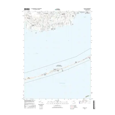
2016 Map of Sayville
USGS Topo · Published 2016About this map
The South Shore of Long Island is defined here by the barrier beach of Fire Island National Seashore, separating the mainland from the Atlantic Ocean. Inland, established communities like Sayville, West Sayville, and Bayport are connected by the Long Island railroad and Montauk Hwy. This coastal landscape reveals a mix of residential growth and maritime heritage, where historic sites like Union Cem and Saint Ann's Cem sit near natural features like Mill Pond and Greenes Lake. Along the barrier island, seasonal settlements such as Cherry Grove, Fire Island Pines, and Water Island are accessible via the Great South Bay, highlighting the unique transport patterns of these automobile-free communities. From the marshes of Ludlows Creek to the shoreline at Sayville Bathing Beach, the map captures the late-twentieth-century character of these iconic Suffolk County locales.
Find a feature on this map
135 named features on this map. Tap any name to fly to it.
Don’t see what you’re looking for? This feature index may not catch every label — zoom into the map to look around manually.
Map Details
Editions of this 2016 Sayville Map
This is the sole edition of this map. No revisions or reprints were ever made.
Other maps of this area

1902 · Setauket
USGS Topo · 1:62,500

1902 · Fire Island
USGS Topo · 1:62,500

1903 · Fire Island
USGS Topo · 1:62,500

1904 · Setauket
USGS Topo · 1:62,500

1904 · Islip
USGS Topo · 1:125,000

1904 · Moriches
USGS Topo · 1:62,500

1919 · Setauket
USGS Topo · 1:62,500

1942 · Islip
USGS Topo · 1:125,000

1944 · Bay Shore East
USGS Topo · 1:24,000

1947 · Bellport
USGS Topo · 1:24,000