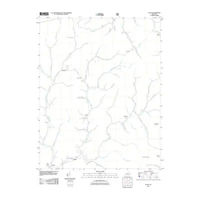
2011 Map of Scalf
USGS Topo · Published 2011About this map
Scalf Post Office and the small settlement of Scalf sit at the center of this mountain landscape, where the Middle Fork Stinking Creek meets its various tributaries. The area is defined by a dense network of branches and forks, including the Stinking Creek which winds past Walker and Dewitt in the southwest. This 2011 survey documents a community tied deeply to the local topography, with roads like Mill Creek-Hubbards Fork Rd and Turkey Fork Rd tracing the narrow valleys between prominent rises. Genealogists may find interest in the Mills-Messer Cemetery located near Mills, or the distribution of post offices across the rural landscape at Walker Post Office and Dewitt Post Office. The map captures the enduring geography of Knox County, from the high point of Huckleberry Knob to the gaps at Caney Gap and Greasy Gap.
Find a feature on this map
75 named features on this map. Tap any name to fly to it.
Don’t see what you’re looking for? This feature index may not catch every label — zoom into the map to look around manually.
Map Details
Editions of this 2011 Scalf Map
This is the sole edition of this map. No revisions or reprints were ever made.
Other maps of this area

1886 · Cumberland Gap
USGS Topo · 1:125,000

1888 · Cumberland Gap
USGS Topo · 1:125,000

1891 · Manchester
USGS Topo · 1:125,000

1891 · Cumberland Gap
USGS Topo · 1:125,000

1903 · Pineville
USGS Topo · 1:48,000

1952 · Hima
USGS Topo · 1:24,000

1952 · Fount
USGS Topo · 1:24,000
1952 · Artemus
USGS Topo · 1:24,000
1954 · Ogle
USGS Topo · 1:24,000
1954 · Pineville
USGS Topo · 1:24,000