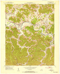
1952 Map of Artemus
USGS Topo · Published 1954About this map
The Cumberland River cuts a deep, winding path through this Knox County landscape, where the local economy in the early 1950s was defined by a mix of coal mining and natural gas extraction. Dense clusters of Gas Wells are concentrated around Himyar and Flat Lick, while a notable Strip Mine marks the hills above Turkey Creek. The region's social fabric is visible in its numerous small settlements and family-named landmarks, such as Yeager (Bimble PO) and the Turkey Creek Mission. The Louisville and Nashville railroad follows the river's bends, serving industrial sites and towns like Artemus. This era shows a transition in local education, with several small schools still active across the hollows, including the Lower Coalport Sch and Dean Sch. The rugged topography is etched with named branches and hollows like Hogpen Hollow and Pigeon Roost Branch, which dictated the placement of early homesteads and cemeteries.
Find a feature on this map
72 named features on this map. Tap any name to fly to it.
Don’t see what you’re looking for? This feature index may not catch every label — zoom into the map to look around manually.
Map Details
Editions of this 1952 Artemus Map
2 editions found
Other maps of this area

1886 · Cumberland Gap
USGS Topo · 1:125,000

1888 · Cumberland Gap
USGS Topo · 1:125,000

1891 · Cumberland Gap
USGS Topo · 1:125,000

1903 · Pineville
USGS Topo · 1:48,000

1903 · Middlesboro
USGS Topo · 1:48,000

1927 · Middlesboro
USGS Topo · 1:62,500

1930 · Middlesboro
USGS Topo · 1:62,500

1952 · Barbourville
USGS Topo · 1:24,000

1952 · Heidrick
USGS Topo · 1:24,000

1952 · Fount
USGS Topo · 1:24,000