
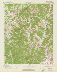
1952 Map of Heidrick
USGS Topo · Published 1953About this map
Richland Creek and its many winding tributaries define this mid-century landscape in the heart of the Kentucky coalfields. The map captures a moment of active industrial transition, where several Strip Mine operations and Strip Mines mark the ridgelines near Kirby Mtn and Gillam Hill. This extraction economy exists alongside a dense network of traditional rural institutions, including the Knox Fork Sch and Scott Chapel.
Find a feature on this map
83 named features on this map. Tap any name to fly to it.
Don’t see what you’re looking for? This feature index may not catch every label — zoom into the map to look around manually.
Map Details
Editions of this 1952 Heidrick Map
2 editions found
Other maps of this area

1886 · Cumberland Gap
USGS Topo · 1:125,000

1888 · Cumberland Gap
USGS Topo · 1:125,000

1890 · Williamsburg
USGS Topo · 1:125,000

1891 · Manchester
USGS Topo · 1:125,000

1891 · Cumberland Gap
USGS Topo · 1:125,000

1893 · London
USGS Topo · 1:125,000

1894 · Williamsburg
USGS Topo · 1:125,000

1897 · London
USGS Topo · 1:125,000

1952 · Corbin
USGS Topo · 1:24,000

1952 · Barbourville
USGS Topo · 1:24,000