
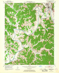
1952 Map of Barbourville
USGS Topo · Published 1953About this map
Cumberland River loops define the landscape south of Barbourville, where the Louisville and Nashville railroad follows the valley floor toward the Knox and Whitley county line. The 1952 landscape is marked by a transition from the collegiate grounds of Union College to the hillsides of Walker Memorial State Park. Local life and family history are deeply embedded in the terrain, documented through numerous country schools like Mackey Sch and Ketchen Sch, and several rural churches such as Apple Grove Ch and Paint Hill Ch. Small settlements like Dishman Springs, Swanpond, and Bryants Store serve as focal points for the dispersed population. Topographical details reveal early industrial activity, including Strip Mine locations near the Cumberland River, while dozens of family cemeteries like Glasscock Cem and Warfield Cem provide invaluable data for genealogical research.
Find a feature on this map
67 named features on this map. Tap any name to fly to it.
Don’t see what you’re looking for? This feature index may not catch every label — zoom into the map to look around manually.
Map Details
Editions of this 1952 Barbourville Map
2 editions found
Other maps of this area

1886 · Cumberland Gap
USGS Topo · 1:125,000

1888 · Cumberland Gap
USGS Topo · 1:125,000

1890 · Williamsburg
USGS Topo · 1:125,000

1891 · Cumberland Gap
USGS Topo · 1:125,000

1894 · Williamsburg
USGS Topo · 1:125,000

1952 · Corbin
USGS Topo · 1:24,000

1952 · Heidrick
USGS Topo · 1:24,000

1952 · Fount
USGS Topo · 1:24,000

1952 · Saxton
USGS Topo · 1:24,000

1952 · Rockholds
USGS Topo · 1:24,000