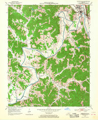
1952 Map of Barbourville
USGS Topo · Published 1968About this map
The Cumberland River cuts a dramatic path through this Knox County landscape, most notably at the sharp oxbow of Horseshoe Bend. The 1952 field check captures Barbourville as a regional hub, featuring the campus of Union College and the proximity of Walker Memorial State Park. The river valley is flanked by a dense network of hollows and gaps, where numerous family cemeteries and small rural schools, such as Dishman Sch and Kitchen Sch, indicate a deeply rooted community structure before modern consolidation.
Find a feature on this map
72 named features on this map. Tap any name to fly to it.
Don’t see what you’re looking for? This feature index may not catch every label — zoom into the map to look around manually.
Map Details
Editions of this 1952 Barbourville Map
2 editions found
Other maps of this area

1886 · Cumberland Gap
USGS Topo · 1:125,000

1888 · Cumberland Gap
USGS Topo · 1:125,000

1890 · Williamsburg
USGS Topo · 1:125,000

1891 · Cumberland Gap
USGS Topo · 1:125,000

1894 · Williamsburg
USGS Topo · 1:125,000

1952 · Corbin
USGS Topo · 1:24,000

1952 · Barbourville
USGS Topo · 1:24,000

1952 · Heidrick
USGS Topo · 1:24,000

1952 · Fount
USGS Topo · 1:24,000

1952 · Saxton
USGS Topo · 1:24,000