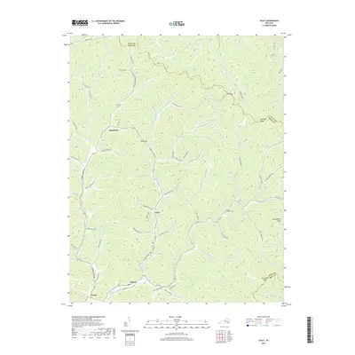
2019 Map of Scalf
USGS Topo · Published 2019About this map
Stinking Cr winds through a landscape of deep hollows and narrow ridges in this 2019 survey of Knox County. Small settlements such as Scalf, Hammond, Walker, and Dewitt are established along the valley floors, connected by a network of rural roads that trace the creek beds and gap crossings. This modern topo map documents the persistent geography of these Appalachian communities, where family and local heritage are anchored by landmarks like the Mills-Messer Cem. Elevated terrain features, including Huckleberry Knob and The Three Knobs, define the eastern portion of the quadrangle near the Bell County line. The map illustrates how transportation continues to follow the natural breaks in the mountain chain, utilizing passes like Clay Gap and Caney Gap to navigate the prominent Kentucky Ridge.
Find a feature on this map
90 named features on this map. Tap any name to fly to it.
Don’t see what you’re looking for? This feature index may not catch every label — zoom into the map to look around manually.
Map Details
Editions of this 2019 Scalf Map
This is the sole edition of this map. No revisions or reprints were ever made.
Other maps of this area

1886 · Cumberland Gap
USGS Topo · 1:125,000

1888 · Cumberland Gap
USGS Topo · 1:125,000

1891 · Manchester
USGS Topo · 1:125,000

1891 · Cumberland Gap
USGS Topo · 1:125,000

1903 · Pineville
USGS Topo · 1:48,000

1952 · Hima
USGS Topo · 1:24,000

1952 · Fount
USGS Topo · 1:24,000
1952 · Artemus
USGS Topo · 1:24,000
1954 · Ogle
USGS Topo · 1:24,000
1954 · Pineville
USGS Topo · 1:24,000