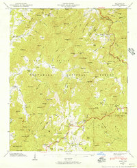
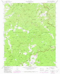
1946 Map of Scaly
USGS Topo · Published 1957About this map
Nantahala National Forest land dominates this 1940s landscape, where small mountain communities like Fulchertown, Tumblerville, and Scaly are scattered among a complex network of ridges and gaps. The map records a way of life centered on small-scale agriculture and industry, evident in landmarks such as Watkins Mill and the Gold Mine near Gold Mine Branch. Local spiritual and civic life is anchored by Drymans Chapel, Tessentee Ch, and the Scaly Sch. Numerous family cemeteries, including Stiles Cem and Mt Moriah Cem, provide critical data for genealogical research. The drainage patterns of the Cullasaja River and Tessentee Creek dictate the settlement locations, with homes following the narrow valleys between peaks like The Pinnacle and High Holly. A lookout tower on Little Scaly stands as a sentinel over the Blue Valley region.
Find a feature on this map
156 named features on this map. Tap any name to fly to it.
Don’t see what you’re looking for? This feature index may not catch every label — zoom into the map to look around manually.
Map Details
Editions of this 1946 Scaly Map
5 editions found
Other maps of this area

1886 · Walhalla
USGS Topo · 1:125,000

1891 · Cowee
USGS Topo · 1:125,000

1892 · Walhalla
USGS Topo · 1:125,000

1896 · Walhalla
USGS Topo · 1:125,000

1897 · Cowee
USGS Topo · 1:125,000

1907 · Cowee
USGS Topo · 1:125,000

1935 · Franklin
USGS Topo · 1:24,000

1935 · Prentiss
USGS Topo · 1:24,000

1935 · Dillard
USGS Topo · 1:24,000

1935 · Scaly
USGS Topo · 1:24,000