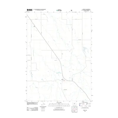
2012 Map of Scenic
USGS Topo · Published 2012About this map
Scenic sits at a crossroads in the western South Dakota Badlands, where the landscape transitions between the high plateau of Kube Table and the eroded depths of the Scenic Basin. The settlement's proximity to the Scenic Cem and the natural drainage of Bear Cr defines its geographical context. This 2012 survey illustrates a sparse ranching and rural infrastructure, characterized by long section-line roads like Spring Draw Rd and Hart Table Rd. The terrain is marked by significant elevation changes, particularly where the plateau drops off into the basin. Local transit and land access are facilitated by a network of secondary routes, including Sage Creek Rd and Bear Creek Rd, which navigate the draws and creek beds that feed into Cain Cr to the south.
Find a feature on this map
17 named features on this map. Tap any name to fly to it.
Don’t see what you’re looking for? This feature index may not catch every label — zoom into the map to look around manually.
Map Details
Editions of this 2012 Scenic Map
This is the sole edition of this map. No revisions or reprints were ever made.
Other maps of this area

1950 · Sheep Mountain Table
USGS Topo · 1:24,000

1950 · Imlay
USGS Topo · 1:24,000

1951 · Heutmacher Table
USGS Topo · 1:24,000

1954 · Scenic
USGS Topo · 1:24,000

1954 · Creston
USGS Topo · 1:24,000

1954 · Scenic SW
USGS Topo · 1:24,000

1954 · Brennan Flat
USGS Topo · 1:24,000

1954 · Quinn Table
USGS Topo · 1:24,000

1955 · Hot Springs
USGS Topo · 1:250,000
1960 · Quinn Table SW
USGS Topo · 1:24,000