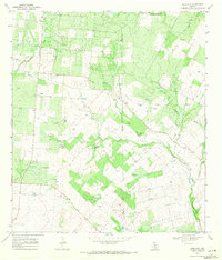
1968 Map of Schattel
USGS Topo · Published 1971About this map
Kyote Oil Field and the northern reaches of the Charlotte Oil Field dominate this 1960s landscape along the border of Frio and Atascosa counties. The geography is defined by a dense network of extraction infrastructure, where numerous wells and a Pipeline cut across the drainage basins of Lagunillas Creek and the West Fork Big Foot Creek. Near the small settlement of Schattel, the presence of a Landing Strip and Pumping Sta reflects the industrial character of the rural South Texas economy during this period.
Find a feature on this map
18 named features on this map. Tap any name to fly to it.
Don’t see what you’re looking for? This feature index may not catch every label — zoom into the map to look around manually.
Map Details
Editions of this 1968 Schattel Map
This is the sole edition of this map. No revisions or reprints were ever made.
Other maps of this area

1934 · Schattel
USGS Topo · 1:62,500

1942 · Natalia
USGS Topo · 1:62,500

1953 · Crystal City
USGS Topo · 1:250,000

1954 · San Antonio
USGS Topo · 1:250,000

1955 · Crystal City
USGS Topo · 1:250,000

1956 · Jourdanton
USGS Topo · 1:62,500

1957 · San Antonio
USGS Topo · 1:250,000

1961 · Crystal City
USGS Topo · 1:250,000

1964 · Ghost Hill
USGS Topo · 1:24,000
1964 · Bigfoot
USGS Topo · 1:24,000