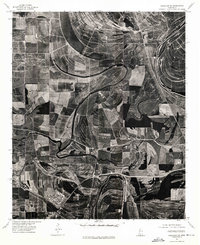
1974 Map of Schlater SE
USGS Topo · Published 1975About this map
Itta Bena and the surrounding Leflore County delta landscape are revealed in this 1974 orthophotograph, which replaces traditional topographic symbols with raw aerial imagery. The serpentine course of the Tallahatchie river dominates the northern and eastern portions of the sheet, its dramatic oxbows and abandoned channels testifying to the shifting nature of the Mississippi alluvial plain. The geometric precision of the agricultural fields creates a stark contrast against the fluid, dark lines of the river and its associated brakes. This specific format—an orthophotogrammetric study—provides researchers with an unfiltered view of land use, vegetation patterns, and drainage systems during the mid-1970s. For those studying the history of the Delta, it offers a literal picture of the rural infrastructure and the relationship between the built environment of the town and the productive landscape that surrounds it.
Find a feature on this map
2 named features on this map. Tap any name to fly to it.
Don’t see what you’re looking for? This feature index may not catch every label — zoom into the map to look around manually.
Map Details
Editions of this 1974 Schlater SE Map
This is the sole edition of this map. No revisions or reprints were ever made.
Other maps of this area

1931 · Schlater
USGS Topo · 1:48,000

1934 · Schlater
USGS Topo · 1:62,500

1936 · Greenwood
USGS Topo · 1:62,500

1939 · Schlater
USGS Topo · 1:62,500

1940 · Seven Pines
USGS Topo · 1:62,500

1940 · Greenwood
USGS Topo · 1:62,500

1953 · Greenwood
USGS Topo · 1:250,000

1956 · Greenwood
USGS Topo · 1:250,000

1957 · Greenwood
USGS Topo · 1:62,500

1957 · Seven Pines
USGS Topo · 1:62,500