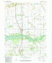
1992 Map of Schneider
USGS Topo · Published 1992About this map
The Kankakee River corridor dominates this region of northwest Indiana, defining the boundary between Lake and Newton counties. In the early 1990s, the landscape shows a complex network of drainage projects, including the Griesel Ditch, Singleton Ditch, and Beaver Lake Ditch, which converted former wetlands into the productive agricultural blocks seen today. The town of Schneider serves as a local hub along the Monon Railroad, while further south, Lake Village and the riverfront Sumava Resorts represent established communities tied to the valley. Cultural landmarks like Sanders Cem and St Augusta Ch provide points of interest for genealogists tracing family histories in these rural townships. Much of the river’s floodplain is preserved within the La Salle State Fish and Wildlife Area, where a Boat Ramp and Campground indicate the area's continued use for recreation and conservation amidst the surrounding farms.
Find a feature on this map
73 named features on this map. Tap any name to fly to it.
Don’t see what you’re looking for? This feature index may not catch every label — zoom into the map to look around manually.
Map Details
Editions of this 1992 Schneider Map
This is the sole edition of this map. No revisions or reprints were ever made.
Other maps of this area

1922 · Momence
USGS Topo · 1:62,500

1924 · Momence
USGS Topo · 1:62,500

1949 · Crete
USGS Topo · 1:62,500

1953 · Leroy
USGS Topo · 1:24,000

1953 · Beecher East
USGS Topo · 1:24,000

1953 · Lowell
USGS Topo · 1:24,000

1953 · Chicago
USGS Topo · 1:250,000

1957 · Chicago
USGS Topo · 1:250,000

1959 · Schneider
USGS Topo · 1:24,000

1959 · Shelby
USGS Topo · 1:24,000