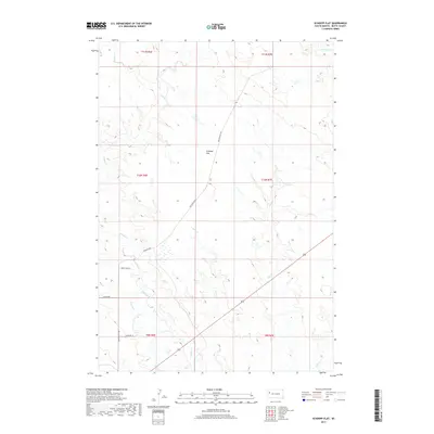
2017 Map of Schoepp Flat
USGS Topo · Published 2017About this map
Schoepp Flat dominates the high prairie of Butte County, South Dakota, in this landscape shaped by ephemeral drainage and grazing land. The area is defined by a series of north-flowing waterways, including Willow Creek, Sand Creek, and Jug Creek, which carve subtle valleys through the open terrain. Human settlement is sparse, centered on the location of Falzerano in the southwest and connected by a network of rural routes like Old Twilight Road and Twilight Road. The presence of the North Lateral canal indicates the importance of water management in this high plains environment, supporting the isolated ranching life marked by family-named tracks such as Jaukkuri Lane and Paint Horse Lane. This survey provides a clear look at the township and range boundaries that organize this part of the West, showing the intersection of T10N and T11N.
Find a feature on this map
18 named features on this map. Tap any name to fly to it.
Don’t see what you’re looking for? This feature index may not catch every label — zoom into the map to look around manually.
Map Details
Editions of this 2017 Schoepp Flat Map
This is the sole edition of this map. No revisions or reprints were ever made.
Other maps of this area

1906 · Vale
USGS Topo · 1:62,500

1913 · Newell
USGS Topo · 1:125,000

1951 · Newell
USGS Topo · 1:24,000

1951 · Vale NE
USGS Topo · 1:24,000

1951 · Vale
USGS Topo · 1:62,500

1953 · Rapid City
USGS Topo · 1:250,000

1957 · Rapid City
USGS Topo · 1:250,000
1959 · Volunteer NW
USGS Topo · 1:24,000
1973 · Owl Butte
USGS Topo · 1:24,000
1977 · Castle Rock
USGS Topo · 1:24,000