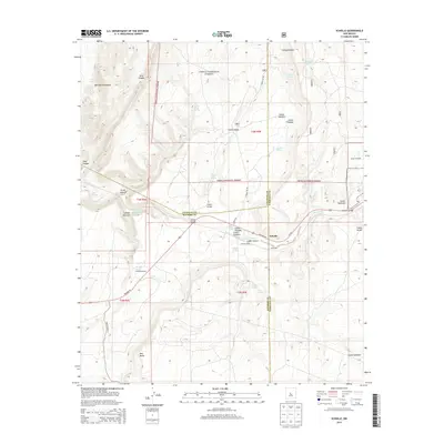
2013 Map of Scholle
USGS Topo · Published 2013About this map
Cibola National Forest encompasses much of this high-desert landscape where Socorro, Torrance, and Valencia counties meet. The small settlement of Scholle sits at the center of a complex network of arroyos and canyons, including the significant Abo Canyon and Abo Arroyo. This area serves as a critical mountain pass, historically facilitating movement through the Manzano Mountains toward the eastern plains. The mapping reveals a reliance on vital water sources in this arid environment, marked by numerous named points such as Bustamante Spring, Dripping Spring, and Saladito Spring. Evidence of land use and ranching infrastructure appears at the Ansley Windmill and the Scholle Siding along the rail corridor. Further south, the prominent Red Butte stands as a distinct landmark against the drainage systems of Cañon Salado and Indian Spring.
Find a feature on this map
38 named features on this map. Tap any name to fly to it.
Don’t see what you’re looking for? This feature index may not catch every label — zoom into the map to look around manually.
Map Details
Editions of this 2013 Scholle Map
This is the sole edition of this map. No revisions or reprints were ever made.
Other maps of this area

1916 · La Joya
USGS Topo · 1:125,000

1917 · Estancia
USGS Topo · 1:125,000

1952 · Tome SE
USGS Topo · 1:24,000

1952 · Becker
USGS Topo · 1:24,000

1952 · Cerro Montoso
USGS Topo · 1:24,000

1954 · Torreon
USGS Topo · 1:62,500

1954 · Socorro
USGS Topo · 1:250,000

1958 · Socorro
USGS Topo · 1:250,000

1962 · Socorro
USGS Topo · 1:250,000

1972 · Chupadera
USGS Topo · 1:24,000