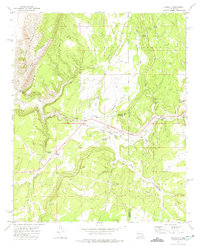
1972 Map of Scholle
USGS Topo · Published 1975About this map
The eastern slopes of the Manzano Mountains dominate this landscape, where the Atchison Topeka and Santa Fe railroad cuts through the heart of Abo Canyon. This corridor is a critical junction of transport and water, centered around the settlement of Scholle and the nearby Scholle Siding. The map reveals a rugged transition between the high forest of the Cibola National Forest and the arroyos that drain toward the Rio Grande basin.
Find a feature on this map
38 named features on this map. Tap any name to fly to it.
Don’t see what you’re looking for? This feature index may not catch every label — zoom into the map to look around manually.
Map Details
Editions of this 1972 Scholle Map
This is the sole edition of this map. No revisions or reprints were ever made.
Other maps of this area

1916 · La Joya
USGS Topo · 1:125,000

1917 · Estancia
USGS Topo · 1:125,000

1952 · Tome SE
USGS Topo · 1:24,000

1952 · Becker
USGS Topo · 1:24,000

1952 · Cerro Montoso
USGS Topo · 1:24,000

1954 · Torreon
USGS Topo · 1:62,500

1954 · Socorro
USGS Topo · 1:250,000

1958 · Socorro
USGS Topo · 1:250,000

1962 · Socorro
USGS Topo · 1:250,000

1972 · Chupadera
USGS Topo · 1:24,000