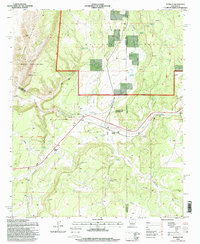
1995 Map of Scholle
USGS Topo · Published 1998About this map
The Cibola National Forest and the high desert of Socorro County converge in this mid-1990s study of the Scholle area. The landscape is defined by its water sources and historical land divisions, including the northern portions of the Casa Colorada Grant and the winding course of the Arroyo Abo. Transportation and resource extraction are central to the region's character, anchored by Scholle Siding along the rail line and the presence of the Abo Mine and Gabaldon Mine.
Find a feature on this map
35 named features on this map. Tap any name to fly to it.
Don’t see what you’re looking for? This feature index may not catch every label — zoom into the map to look around manually.
Map Details
Editions of this 1995 Scholle Map
This is the sole edition of this map. No revisions or reprints were ever made.
Other maps of this area

1916 · La Joya
USGS Topo · 1:125,000

1917 · Estancia
USGS Topo · 1:125,000

1952 · Tome SE
USGS Topo · 1:24,000

1952 · Becker
USGS Topo · 1:24,000

1952 · Cerro Montoso
USGS Topo · 1:24,000

1954 · Torreon
USGS Topo · 1:62,500

1954 · Socorro
USGS Topo · 1:250,000

1958 · Socorro
USGS Topo · 1:250,000

1962 · Socorro
USGS Topo · 1:250,000

1972 · Chupadera
USGS Topo · 1:24,000