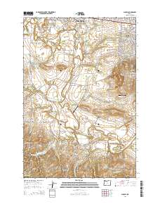
2014 Map of Scholls
USGS Topo · Published 2014About this map
Hillsboro and the surrounding agricultural landscape of Washington County are defined by the winding course of the Tualatin River and its numerous tributaries. This survey captures a mix of established residential centers like Aloha and Hazeldale alongside smaller rural crossroads such as Farmington, Scholls, and Midway. The valley floor is notably dotted with water management features, including the Wellspring Reservoir, Jackson Reservoir, and Wandell Reservoir, which support the region's long-standing farming operations.
Find a feature on this map
150 named features on this map. Tap any name to fly to it.
Don’t see what you’re looking for? This feature index may not catch every label — zoom into the map to look around manually.
Map Details
Editions of this 2014 Scholls Map
This is the sole edition of this map. No revisions or reprints were ever made.
Other maps of this area

1915 · Hillsboro
USGS Topo · 1:62,500

1916 · Tualatin
USGS Topo · 1:62,500

1918 · Hillsboro
USGS Topo · 1:62,500

1939 · Tualatin
USGS Topo · 1:62,500

1940 · Tualatin
USGS Topo · 1:62,500

1940 · Hillsboro
USGS Topo · 1:62,500

1941 · Gales Creek
USGS Topo · 1:62,500

1941 · Yamhill
USGS Topo · 1:62,500

1942 · Yamhill
USGS Topo · 1:62,500

1948 · Vancouver
USGS Topo · 1:250,000