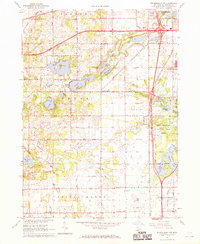
1967 Map of Schoolcraft NW
USGS Topo · Published 1969About this map
Glacial lakes and marshlands define the landscape of south-central Kalamazoo County, where the sprawling Gourdneck State Game Area buffers the expanding suburban boundaries of Portage. The 1960s terrain is characterized by a high density of water bodies, including the clusters of Eagle Lake, Crooked Lake, and Pretty Lake in the western reaches. The small community of Texas Corners serves as a central crossroads, while the mapping of numerous Gravel Pits reflects the local industry of the era. Genealogists and local historians will find value in the precise locations of Hope Cem and Harrison Cem, along with rural landmarks like Calvary Ch and the Boy Scout camp at Camp Rota-Kiwan. The southern portion of the sheet transitions into the township of Prairie Ronde, showing the early outskirts of the village of Schoolcraft.
Find a feature on this map
43 named features on this map. Tap any name to fly to it.
Don’t see what you’re looking for? This feature index may not catch every label — zoom into the map to look around manually.
Map Details
Editions of this 1967 Schoolcraft NW Map
3 editions found
Other maps of this area

1916 · Kalamazoo
USGS Topo · 1:62,500

1918 · Kalamazoo
USGS Topo · 1:62,500

1922 · Schoolcraft
USGS Topo · 1:62,500

1943 · Kalamazoo
USGS Topo · 1:62,500

1943 · Schoolcraft
USGS Topo · 1:62,500

1944 · Marcellus
USGS Topo · 1:62,500

1946 · Marcellus
USGS Topo · 1:62,500

1946 · Gobles
USGS Topo · 1:62,500

1948 · Gobles
USGS Topo · 1:62,500

1949 · Gobles
USGS Topo · 1:62,500