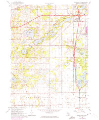
1967 Map of Schoolcraft NW
USGS Topo · Published 1974About this map
The glacial landscape of Texas and Prairie Ronde townships is defined by an intricate network of kettle lakes and wetlands south of Oshtemo. During this mid-century period, the expansion of Portage begins to press westward, seen in the purple-tinted urban developments near Kalamazoo Valley Community College and the various residential clusters around Texas Corners. Water features dominate the local geography, ranging from the recreational shores of Eagle Lake and Pretty Lake to the protected wetlands of the Gourdneck State Game Area.
Find a feature on this map
51 named features on this map. Tap any name to fly to it.
Don’t see what you’re looking for? This feature index may not catch every label — zoom into the map to look around manually.
Map Details
Editions of this 1967 Schoolcraft NW Map
3 editions found
Other maps of this area

1916 · Kalamazoo
USGS Topo · 1:62,500

1918 · Kalamazoo
USGS Topo · 1:62,500

1922 · Schoolcraft
USGS Topo · 1:62,500

1943 · Kalamazoo
USGS Topo · 1:62,500

1943 · Schoolcraft
USGS Topo · 1:62,500

1944 · Marcellus
USGS Topo · 1:62,500

1946 · Marcellus
USGS Topo · 1:62,500

1946 · Gobles
USGS Topo · 1:62,500

1948 · Gobles
USGS Topo · 1:62,500

1949 · Gobles
USGS Topo · 1:62,500