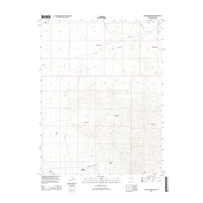
2014 Map of Schoolmarm Basin
USGS Topo · Published 2014About this map
Schoolmarm Basin and the surrounding high desert of Lincoln County are defined by a network of springs and seeps essential to the arid environment. The map records numerous water sources such as Hidden Treasure Spring, Happy Hollow Spring, and Middleton Seeps scattered across the basin floor. This reliance on groundwater is typical for the eastern Nevada landscape, where human activity is often dictated by these rare hydration points. Transport across the terrain is facilitated by several named routes, including the historical Stage Coach Rd and Atlanta Rd, which weave through the flats and canyons. The topographical prominence of Mt Wilson and Squaw Knoll provides natural orientation points for travelers moving between Cedar Flat and the high ridges of the Wilson Creek Range.
Find a feature on this map
32 named features on this map. Tap any name to fly to it.
Don’t see what you’re looking for? This feature index may not catch every label — zoom into the map to look around manually.
Map Details
Editions of this 2014 Schoolmarm Basin Map
This is the sole edition of this map. No revisions or reprints were ever made.
Other maps of this area

1915 · Bristol Range
USGS Topo · 1:62,500

1917 · Bristol Range
USGS Topo · 1:62,500

1956 · Lund
USGS Topo · 1:250,000

1960 · Lund
USGS Topo · 1:250,000
1970 · Mt. Wilson
USGS Topo · 1:24,000

1970 · Parsnip Peak
USGS Topo · 1:24,000
1971 · Bristol Range NE
USGS Topo · 1:24,000

1973 · Schoolmarm Basin
USGS Topo · 1:24,000

1973 · Horse Corral Pass
USGS Topo · 1:24,000

1973 · Atlanta
USGS Topo · 1:24,000